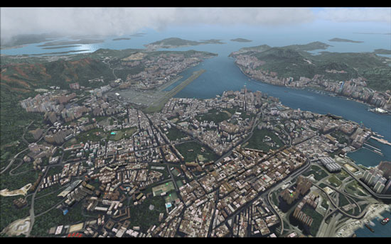
Kai Tak (VHHX) , Hong Kong
China
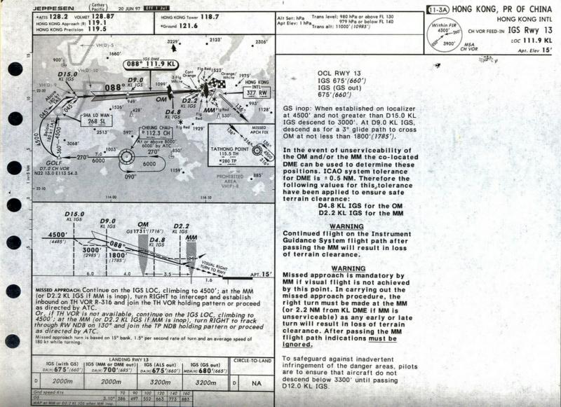
Kai Tak (VHHX) Approach chart, RWY 13
DETAILS:
Kai closed on 6 July 1998 due to pollutio in resedential areas and hindrance of many activities of the residents and airport even though the airport handled 29.5 million passengers, plus 1.56 million tonnes of freight, making it the third busiest airport in the world in terms of international passenger traffic, and first in terms of international cargo throughput.A small ceremony celebrating the end of the airport was held inside the control tower after the last flight took off. A speech was given, and the controller's last words as he switched off the runway lights were "Goodbye Kai Tak, and thank you".
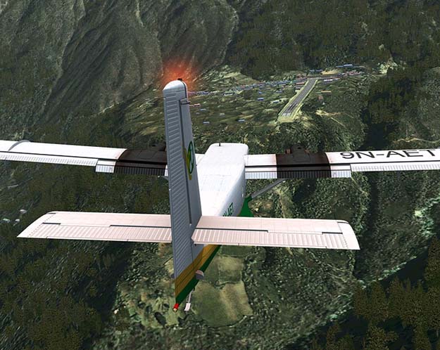
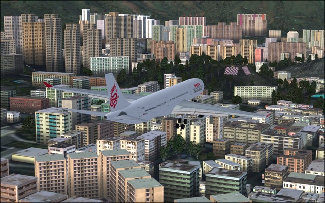
Though the runway is now closed in the real world it is still open in FSX. The landing approach using runway 13 at Kai Tak was spectacular and world-famous. To land on runway 13, an aircraft first took a descent heading northeast. The aircraft would pass over the crowded harbour, and then the very densely populated areas of Western Kowloon. This leg of the approach was guided by an IGS (Instrument Guidance System, a modified ILS) after 1974. Upon reaching a small hill marked with a checkerboard in red and white, used as a visual reference point on the final approach (in addition to the middle marker on the Instrument Guidance System), the pilot needed to make a 47° visual right turn to line up with the runway and complete the final leg. The aircraft would be just two nautical miles (3.7 km) from touchdown, at a height of less than 1,000 feet (300 m) when the turn was made. Typically the plane would enter the final right turn at a height of about 650 feet (200 m) and exit it at a height of140 feet (43 m) to line up with the runway. This manoeuver has become widely known in the piloting community as the "Hong Kong Turn" or "Checkerboard Turn".
From a spectator's point of view, watching large Boeing 747s banking at low altitudes and taking big crab angles during their final approaches was quite thrilling. Despite the difficulty, the runway 13 approach was nonetheless used most of the time due to the prevailing wind direction in Hong Kong.Due to the turn in final approach, ILS was not available for runway 13 and landings had to follow a visual approach. This made the runway unusable in low visibility conditions.
IN FSX:
Once again, this is an extremely challenging non-precision approach ... many experienced pilots had their aircraft damaged at touchdown, so that's another great way to practice your visual landings and turns skills! The IGS is not available on FS2004 scenery by default, but there are some small add-ons that can add it easily - use Google and find one of them before you continue. This approach plate provides the pilot the average terrain altitude and a on-scale map - make good use of it. Now, choose your best 747-400 add-on and try this approach!
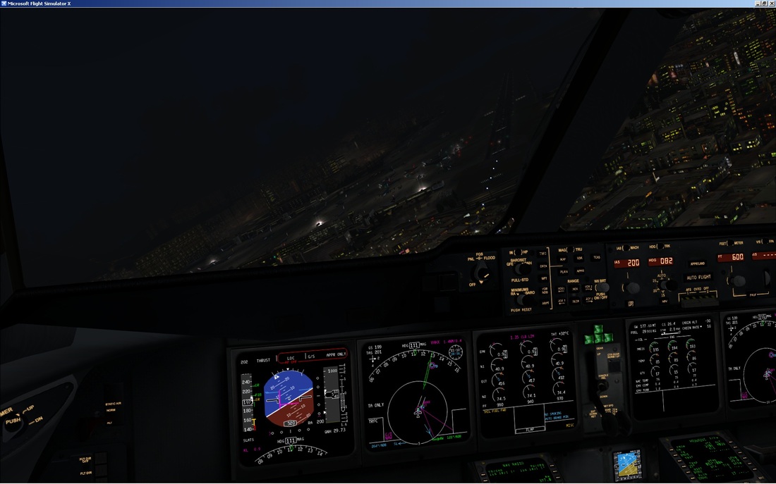
The IGS RNW 13 approach starts at the CHEUNG CHAU VOR (CH - 112.30), at 8000 feet - there is also a published holding point for this VOR. When you are ready, pass the VOR station at heading 270 and go straight ahead for 7 more miles, descending at the same time to 6000 feet. As you will probably be over 180 knots, make a turn to heading 045 to intercept the localizer (KL - 088º - 111.9) and start a descent to 4500 feet. Once you have intercepted the localizer, things are much easier: the IGS should work like an ordinary ILS. Follow both localizer and glideslope correctly and you should make the outer marker at about 1700 feet. You should soon realize that the runway is not aligned to the IGS, but about 45 degrees off course!!
Strange, for sure, but that's the way it should be. Now comes the most challenging part of this approach - you must remain concentrated and act quickly and smoothly should anything not normal happen. Continue on the GS and LOC until the middle marker, where you should have visual contact with the checkerboard; if you don't, go missed immediately! Shortly after you hard the middle marker beeps, start a right turn to align with the runway - watch your speed, altitude and turn rate carefully in order align correctly and safely. The HONG KONG NDB (RW - 377) is just in front of the runwnay, so you can tune it for a more precise orientation. After you have turned and aligned with the runway, follow the PAPI lights to ensure a correct glidepath and landing. It takes many tries to align and land perfectly, especially when you have crosswinds, but the sensation of accomplishment after you have landed correctly is amazing.
Get on the simulator and fly the most challenging approach that existed in the world; do it correctly and you can consider yourself an outstanding pilot!
BEST ADDON SCENERY TO TRY THIS APPROACH:
Kai Tak by Fly Tampa
Kai closed on 6 July 1998 due to pollutio in resedential areas and hindrance of many activities of the residents and airport even though the airport handled 29.5 million passengers, plus 1.56 million tonnes of freight, making it the third busiest airport in the world in terms of international passenger traffic, and first in terms of international cargo throughput.A small ceremony celebrating the end of the airport was held inside the control tower after the last flight took off. A speech was given, and the controller's last words as he switched off the runway lights were "Goodbye Kai Tak, and thank you".
Though the runway is now closed in the real world it is still open in FSX. The landing approach using runway 13 at Kai Tak was spectacular and world-famous. To land on runway 13, an aircraft first took a descent heading northeast. The aircraft would pass over the crowded harbour, and then the very densely populated areas of Western Kowloon. This leg of the approach was guided by an IGS (Instrument Guidance System, a modified ILS) after 1974. Upon reaching a small hill marked with a checkerboard in red and white, used as a visual reference point on the final approach (in addition to the middle marker on the Instrument Guidance System), the pilot needed to make a 47° visual right turn to line up with the runway and complete the final leg. The aircraft would be just two nautical miles (3.7 km) from touchdown, at a height of less than 1,000 feet (300 m) when the turn was made. Typically the plane would enter the final right turn at a height of about 650 feet (200 m) and exit it at a height of140 feet (43 m) to line up with the runway. This manoeuver has become widely known in the piloting community as the "Hong Kong Turn" or "Checkerboard Turn".
From a spectator's point of view, watching large Boeing 747s banking at low altitudes and taking big crab angles during their final approaches was quite thrilling. Despite the difficulty, the runway 13 approach was nonetheless used most of the time due to the prevailing wind direction in Hong Kong.Due to the turn in final approach, ILS was not available for runway 13 and landings had to follow a visual approach. This made the runway unusable in low visibility conditions.
IN FSX:
Once again, this is an extremely challenging non-precision approach ... many experienced pilots had their aircraft damaged at touchdown, so that's another great way to practice your visual landings and turns skills! The IGS is not available on FS2004 scenery by default, but there are some small add-ons that can add it easily - use Google and find one of them before you continue. This approach plate provides the pilot the average terrain altitude and a on-scale map - make good use of it. Now, choose your best 747-400 add-on and try this approach!
The IGS RNW 13 approach starts at the CHEUNG CHAU VOR (CH - 112.30), at 8000 feet - there is also a published holding point for this VOR. When you are ready, pass the VOR station at heading 270 and go straight ahead for 7 more miles, descending at the same time to 6000 feet. As you will probably be over 180 knots, make a turn to heading 045 to intercept the localizer (KL - 088º - 111.9) and start a descent to 4500 feet. Once you have intercepted the localizer, things are much easier: the IGS should work like an ordinary ILS. Follow both localizer and glideslope correctly and you should make the outer marker at about 1700 feet. You should soon realize that the runway is not aligned to the IGS, but about 45 degrees off course!!
Strange, for sure, but that's the way it should be. Now comes the most challenging part of this approach - you must remain concentrated and act quickly and smoothly should anything not normal happen. Continue on the GS and LOC until the middle marker, where you should have visual contact with the checkerboard; if you don't, go missed immediately! Shortly after you hard the middle marker beeps, start a right turn to align with the runway - watch your speed, altitude and turn rate carefully in order align correctly and safely. The HONG KONG NDB (RW - 377) is just in front of the runwnay, so you can tune it for a more precise orientation. After you have turned and aligned with the runway, follow the PAPI lights to ensure a correct glidepath and landing. It takes many tries to align and land perfectly, especially when you have crosswinds, but the sensation of accomplishment after you have landed correctly is amazing.
Get on the simulator and fly the most challenging approach that existed in the world; do it correctly and you can consider yourself an outstanding pilot!
BEST ADDON SCENERY TO TRY THIS APPROACH:
Kai Tak by Fly Tampa
Fly Hong Kong
Madeira (LPMA), Funchal
Portugal
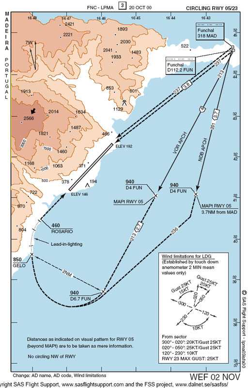
Madeira (LPMA) Approach Chart, RWY 05
DETAILS:
Madeira Airport was officially opened on 18 July 1964. The airport was once infamous for its short runway which, surrounded by high mountains and the ocean, made it a tricky landing for even the most experienced of pilots.
In 1972, the popularity of visiting the island of Madeira increased, so the runway had to be extended, as modern larger aircraft could not land on it. Decisions had to be made to find out where the best place for a runway would be, and they decided that the area where the short runway was, was the best place to extend it, so they had to somehow extend the runway. In the meantime, a brand new terminal was built at the airport in 1973, handling 500,000 passengers.
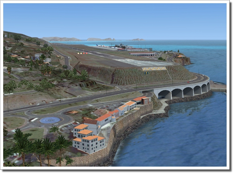
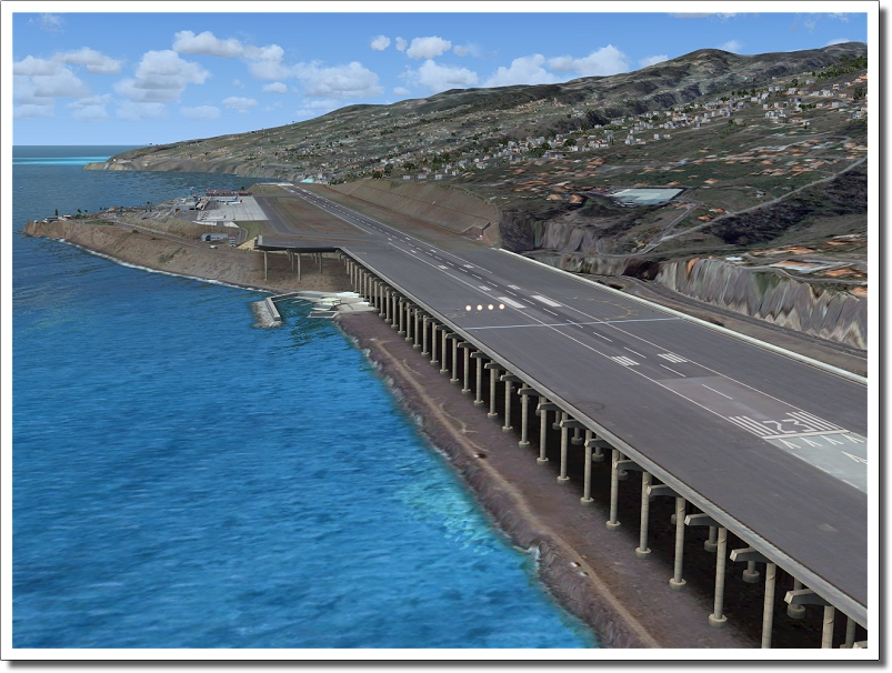
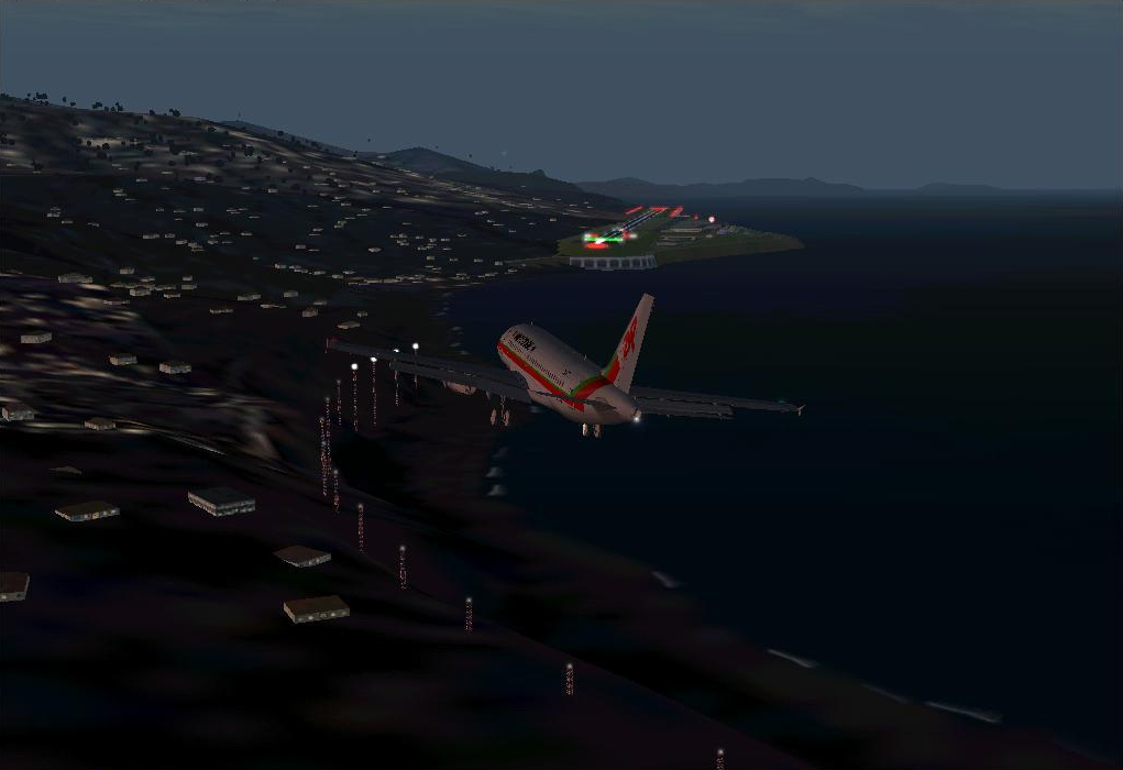
Between 1982 and 1986, Madeira's runway was successfully extended to total 1,800 metres (5,900 ft). The original runway was only 1,600 metres (5,249 ft) in length, but was extended by 200 metres (660 ft) and subsequently rebuilt in 2000, almost doubling the size of the runway, building it out over the ocean. Instead of using landfill, the extension was built on a series of 180 columns, each about 70 metres (230 ft) tall. This airport is also considered the Kai Tak of Europe because of its singular approach to runway 05
The airport has a single terminal which opened in 1973. The terminal has 40 check-in desks, 16 boarding gates and 7 baggage belts. There are no air-bridges so passengers either walk the short distance to the terminal or are taken by shuttle bus. The terminal itself is mostly underground.
EngineeringThe work of extension of Madeira Airport conducted by the Brazilian construction company Andrade Gutierrez, is a work recognised worldwide as one of the most difficult to achieve due to the type of terrain. In 2004, Dr Manabu Ito, President of the International Association of Bridge and Structural Engineering (IABSE) presented in Shanghai, China, the award for 2004 IABSE Outstanding Structure Award which is given only to great works of engineering recognised worldwide.
IN FSX:
Refer the chart given above. To land at RWY 05 you must first fly over the radio beacon called FUNCHAL VOR (FUN - 112.2). Fly the radial 213 from the station, by the time you reach 4 DME you should be at 940 ft and maintain this altitude. Continue on the radial till the DME shows 6.7. At this point start a right turn and head to the beginning of the lead-in-lighting system (fix GELO) which is a continuous right curve. Also start a shallow descent to 850 feet and continue the descent so that you reach the ROSARIO fix at 460 ft. At this point, you should be aligned with the runway. With the help of the PAPI indicator make sure the altitude is correct to perform a perfect landing.
BEST ADDON SCENERY TO TRY THIS APPROACH:
Madeira X by Aerosoft
Madeira Airport was officially opened on 18 July 1964. The airport was once infamous for its short runway which, surrounded by high mountains and the ocean, made it a tricky landing for even the most experienced of pilots.
In 1972, the popularity of visiting the island of Madeira increased, so the runway had to be extended, as modern larger aircraft could not land on it. Decisions had to be made to find out where the best place for a runway would be, and they decided that the area where the short runway was, was the best place to extend it, so they had to somehow extend the runway. In the meantime, a brand new terminal was built at the airport in 1973, handling 500,000 passengers.
Between 1982 and 1986, Madeira's runway was successfully extended to total 1,800 metres (5,900 ft). The original runway was only 1,600 metres (5,249 ft) in length, but was extended by 200 metres (660 ft) and subsequently rebuilt in 2000, almost doubling the size of the runway, building it out over the ocean. Instead of using landfill, the extension was built on a series of 180 columns, each about 70 metres (230 ft) tall. This airport is also considered the Kai Tak of Europe because of its singular approach to runway 05
The airport has a single terminal which opened in 1973. The terminal has 40 check-in desks, 16 boarding gates and 7 baggage belts. There are no air-bridges so passengers either walk the short distance to the terminal or are taken by shuttle bus. The terminal itself is mostly underground.
EngineeringThe work of extension of Madeira Airport conducted by the Brazilian construction company Andrade Gutierrez, is a work recognised worldwide as one of the most difficult to achieve due to the type of terrain. In 2004, Dr Manabu Ito, President of the International Association of Bridge and Structural Engineering (IABSE) presented in Shanghai, China, the award for 2004 IABSE Outstanding Structure Award which is given only to great works of engineering recognised worldwide.
IN FSX:
Refer the chart given above. To land at RWY 05 you must first fly over the radio beacon called FUNCHAL VOR (FUN - 112.2). Fly the radial 213 from the station, by the time you reach 4 DME you should be at 940 ft and maintain this altitude. Continue on the radial till the DME shows 6.7. At this point start a right turn and head to the beginning of the lead-in-lighting system (fix GELO) which is a continuous right curve. Also start a shallow descent to 850 feet and continue the descent so that you reach the ROSARIO fix at 460 ft. At this point, you should be aligned with the runway. With the help of the PAPI indicator make sure the altitude is correct to perform a perfect landing.
BEST ADDON SCENERY TO TRY THIS APPROACH:
Madeira X by Aerosoft
Madeira X
Innsbruck (LOWI) , Tyrol
Austria
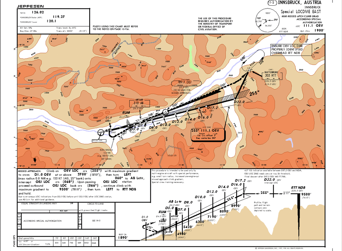
Innsbruck (LOWI) Approach Chart, RWY 26
DETAILS:
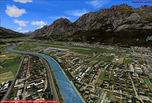
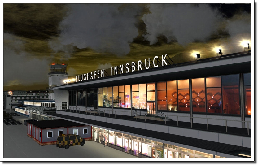
Innsbruck (LOWI) is the largest airport in Tyrol in western Austria. It handles regional flights around the Alps, as well as seasonal international flights to other destinations. During the winter, activity increases significantly, due to the high number of skiers travelling to the region. The airport receives mostly mid-size and smaller jets and props, and see nothing larger than the Boeing 767.Some airlines operate Boeing 757s out of LOWI, and connecting to major airport hubs, such as London's Heathrow International Airport. The approach is very difficult, even more so in the Winter, when the traffic soars. The approach and descent is a very complicated process -- the Alps create vicious winds and currents, which the pilot has to deal with throughout the process. Because there are mountains all around, the plane usually circles the airport, enters a pattern, to decrease both speed and altitude. The terminal is a "shotgun" style, typically using air stairs to deboard/board passengers -- no jetways are present. Their are several de-icing trucks, which de-ice the airframe typically right before engine start, or before obtaining clearance to takeoff.
Innsbruck Airport is well known for having a difficult approach due to surrounding terrain, prohibiting certain aircraft types from operating at the airport.
IN FSX:
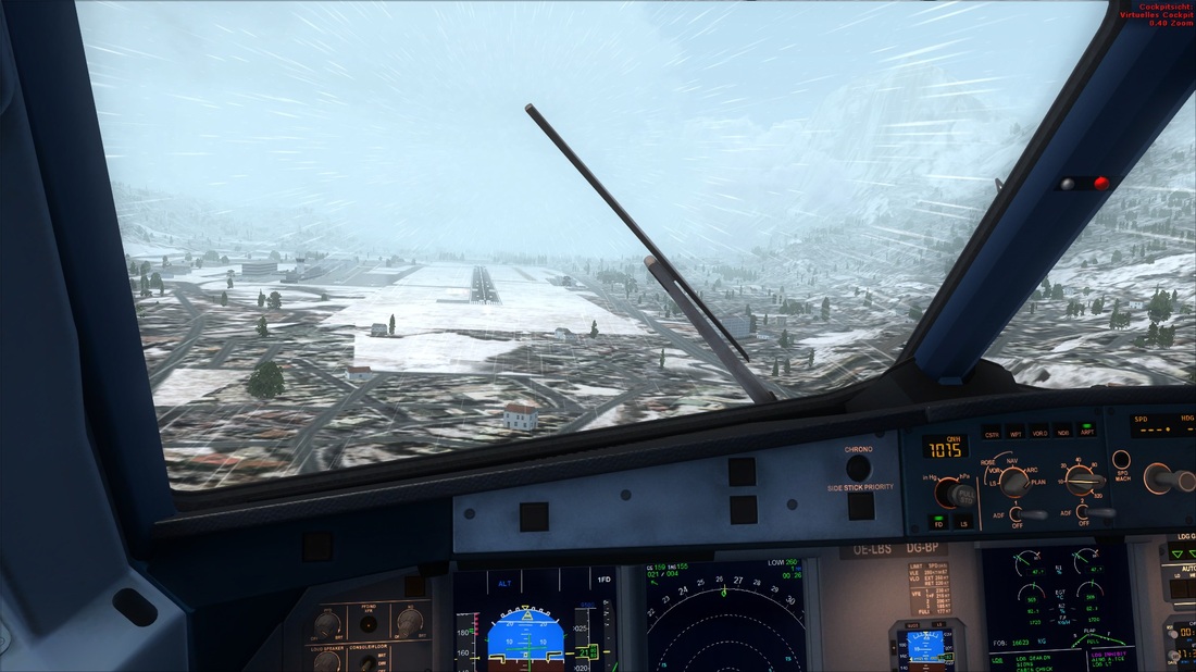
The approach to RWY 08 starts with a localizer, which is not aligned with the runway, and ends with a right turn and visual landing on the airport.
This approach starts at KUHTAI NDB (KTI - 413) at 11500 ft - there is also a published holding point at this NDB. Track the radial 104 from this NDB until you intercept the OEJ LOC/DME (068º - 109.70). Continue on the localizer normally, following the restrictions: DME 17.4 - 10500 feet; DME 14.4 - 9000 feet; DME 11.4 - 7500 feet; DME 6.5 - 5000 feet. Level off at 5000 feet and at exactly DME 4.4 from the localizer, start a right turn to the direction of the runway. At this time, the approach becomes visual and the autopilot goes off! Control the altitude, speed and bank angle in order to reach the runway heading at the right speed and altitude. Then, accomplish normal landing.
BEST ADDON SCENERY TO TRY THIS APPROACH:
Innsbruck X by Aerosoft
Innsbruck (LOWI) is the largest airport in Tyrol in western Austria. It handles regional flights around the Alps, as well as seasonal international flights to other destinations. During the winter, activity increases significantly, due to the high number of skiers travelling to the region. The airport receives mostly mid-size and smaller jets and props, and see nothing larger than the Boeing 767.Some airlines operate Boeing 757s out of LOWI, and connecting to major airport hubs, such as London's Heathrow International Airport. The approach is very difficult, even more so in the Winter, when the traffic soars. The approach and descent is a very complicated process -- the Alps create vicious winds and currents, which the pilot has to deal with throughout the process. Because there are mountains all around, the plane usually circles the airport, enters a pattern, to decrease both speed and altitude. The terminal is a "shotgun" style, typically using air stairs to deboard/board passengers -- no jetways are present. Their are several de-icing trucks, which de-ice the airframe typically right before engine start, or before obtaining clearance to takeoff.
Innsbruck Airport is well known for having a difficult approach due to surrounding terrain, prohibiting certain aircraft types from operating at the airport.
IN FSX:
The approach to RWY 08 starts with a localizer, which is not aligned with the runway, and ends with a right turn and visual landing on the airport.
This approach starts at KUHTAI NDB (KTI - 413) at 11500 ft - there is also a published holding point at this NDB. Track the radial 104 from this NDB until you intercept the OEJ LOC/DME (068º - 109.70). Continue on the localizer normally, following the restrictions: DME 17.4 - 10500 feet; DME 14.4 - 9000 feet; DME 11.4 - 7500 feet; DME 6.5 - 5000 feet. Level off at 5000 feet and at exactly DME 4.4 from the localizer, start a right turn to the direction of the runway. At this time, the approach becomes visual and the autopilot goes off! Control the altitude, speed and bank angle in order to reach the runway heading at the right speed and altitude. Then, accomplish normal landing.
BEST ADDON SCENERY TO TRY THIS APPROACH:
Innsbruck X by Aerosoft
Innsbruck X
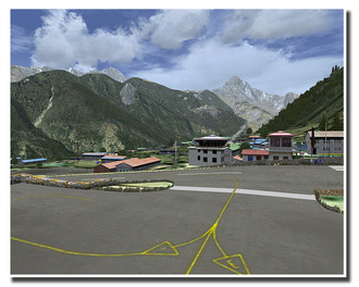
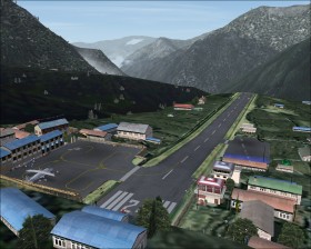
Tenzing-Hillary (VLNK), Lukla
Nepal
DETAILS:
BEST ADDON SCENERY TO TRY THIS APPROACH:
Lukla X by Aerosoft
BEST ADDON SCENERY TO TRY THIS APPROACH:
Lukla X by Aerosoft